Started on the Ohio - Pennsylvania border and headed into
Game lands 285. The terrain would range from your typical flood way to rolling hills
averaging grades between 8% to 18%.
I was a little over dressed and needed to strip some layers,
it warmed up quickly. The overnight low was 52 degrees; bit it was 64 degrees
by the time I got to the trailhead.
I stuffed them into my pack and headed out. It was nice and
nearly void of people. I saw only one couple and they were on their turn around
leg of their hike.
I keep looking at my handheld Garmin 64sx looking at the
elevations and what not. Please always
remember All-trails and all other web-based data is not accurate ever!
I would rate this hike for the average hiker in average
hiker health as an easy hike. When there were steep grade changes, they were
very gradual I thought.
I did not see a lot of wildlife. I did see an adult Lantern
Fly and recorded the GPS coordinates and emailed it to the Depart of
Agriculture of the state of Pennsylvania.
The 12.9 mile hike is what I needed in preparation for the
Monongahela NF trip in 17 days!!
Out on the NCT today I hiked with a good friend, and we only
did seven miles. My Danner Boots sprung a leak! Well, I called them on the way
back and because it was under 90 days they gave me a new pair off the shelf.
It was buggy and muddy on this section. I knew it would be
this way because we saw evidence of the rain that fell this morning. It was
good to get out and see this new short section of the NCT “North Country
Trail”.
I first encountered a section of the NCT here in Ohio. The
trail sections I have encountered have been more remote and take more effort to
hike than other trails. The effort is what makes it all worth it. The
volunteers they have working on this trail system do an amazing job.
So, back to my hike on the NCT. I was looking at challenging
myself physically and mentally with a hike this summer. I looked through to
start with utilizing AllTrails found here https://www.alltrails.com/.
After hiking on the NCT in Beaver Creek State Park I wanted
to see if I can find other sections in Pennsylvania and in New York. I found
several sections of the NCT, but one stood out to me.
This park is in Portersville, Pennsylvania and is big enough
to get away from most of the people. Lake Arthur is in the park. This sees
heavy boat traffic and a lot of people in the summer.
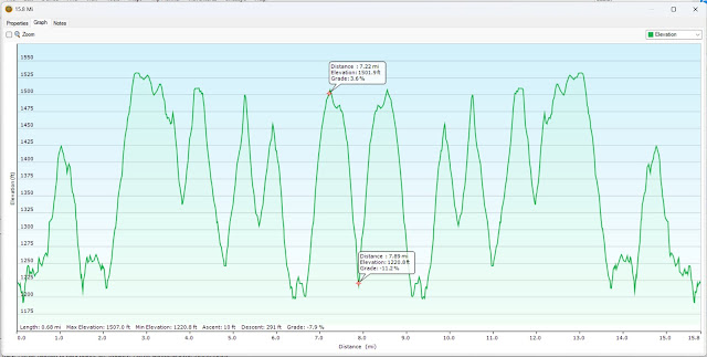
The NCT trail section here has plenty of elevation
deviation. I ascended and descended through out the hike 3300 feet.As you can see in the graphic below it is
quite the roller coaster ride. There were only two climbs and descents that
were tough I thought.
I also wanted to mention I don’t think a lot of people out
there are used to this, let me explain. When you get into an area that has a
trail that goes up and down for several hundred feet these trails become rivers
and creeks when it rains.
When this happens the dirt and sometimes the smaller rocks
get washed away. If you in an area with clay this can be very slippery when
wet.For example, every step you take
must be deliberate and caution must be taken.You will see in the videos water still running down the hills. The
creeks and springs were all running strong. I love the sound of running water
there is something about it that just makes me feel at peace.
I deliberately chose to go no faster than 2.0 mph on this
hike. I wanted to finish the entire length of the trail I laid out in Garmin
Basecamp. I had calculated it was 16 miles long, but ended up being 17.10 miles.I place mile marker waypoints along the trail
to assist myself to monitor how I was doing.
I would make a conscious effort like at mile 6 to do a
system check on myself. I would ask how do I feel? Do I feel hydrated? Am I
drinking enough water? How much water do I have left?
Since I do a lot of my activities solo, I need to make sure
I do these system checks. Out of the three people I saw on the trail today most
of the time I saw no one.
Yes, so please use common sense and be prepared.
I saw only wone deer today and a bevy of hoof prints. The
mosquitoes were annoying but as wet as it was it could have been a lot worse.
I saw two interesting birds yesterday. I saw this bird down
in Beaver Creek State and along the trail.The one was an American Redstart. I thought at first it was a mismarked
Baltimore Oriole. The next bird I saw I thought I was seeing things. Its body
was bright but deep red in color and its wings were black. What I saw was male
Scarlet Tanager.
I try and be very aware of animals that I see and hear
around me. This was neat to see these two birds. Especially the Red Tanager. I
thought my eyes were playing tricks on me.
This would be one of the highlights of the day. At about
mile 16.15 I was ready for the hike to end. I was very hydrated, but my almost
60 yo body was over it. My dogs were barking, and I was done. I call it zombie
hiking. This is where your body knows what has to be done to complete the task,
but your brain is off! Lol
I hope you enjoyed the write-up and the artwork and be well.
I am headed to Pennsylvania for a 15.8 Mile hike on 6.21.2025
I will be hiking another section of the North Country Trail
(NCT).Between Alltrails and Garmin Basecamp I have laid out the hike.
It is telling me that the ascent and descent will be over
3300 feet. I am going to see how it goes through the hike. I would like to
complete it on Saturday.We will see I have
never been there.
I am taking two water bladders with me in my pack. The one
bladder is 3 liters and the other is 2 liters. I am only going to carry a total
of 4 and not 5.
I have not covered terrain like this since the service and that’s
been decades ago.I will monitor my pace
and keep it slow and steady.Even at a 2-mph
pace that’s 7.9 hours! I will pack my head lamp just in case lol “not really
funny, but kind of is”.